|
|
|
|
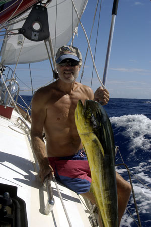
Tuamotu Archipelago The Tuamotus are a group of 78 coral atolls that extend almost 1,000 miles in a NW-SE direction and spread across 150 degrees of longitude. The atolls have little greenery except for some palm trees and low brush on the motus (islets) that are clustered around the reefs. These islands have been called the "Low or Dangerous Archipelago" and were often bypassed as being too dangerous to approach in the days before GPS and electronic charting. Care must still be taken and approaches through the passes are dependent on the time of the tides to avoid a contrary current through the pass, and the sun overhead to enable accurate sightings of the coral heads that often scatter the passes and the lagoon. Our passage from Nuku Hiva to the northwestern Tuamotus was about 500 nm which we made in less than 4 days. We had good winds averaging 140 nm per day and an uneventful passage except for a "loud bang" on the port hull our third night out. There was no damage noted and because of the cloud covered dark night sky, we could see nothing in the water. We're pretty sure it must have been a whale sleeping on the surface of the sea. Had it been a clearer night, we would have been able to see it's rhythmic spouting as it slept. The rest of the passage was benign and the fishing remained excellent. Here the Captain adds another mahi-mahi to the collection.
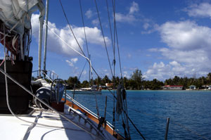
As we got closer to the archipelago, it was determined that the atoll of Ahe (also called Peacock Island) would be where we would make landfall. We could reach the pass at slack tide which is recommended as there are strong tidal currents in the pass. We also would arrive with the sun overhead to enable us to have a better view of the coral heads that scatter the pass and lagoon. This is a wooded atoll, 13 miles long and 5 miles wide with less than 200 inhabitants in the village. As we entered Passe Reianui, the only pass into the lagoon, Robert climbed the mast and sat in the spreaders to identify the deeper water over the sandbar and spot the coral heads. Once through the pass, we continued on to the anchorage, threading a route around the exposed coral heads.
We anchored off the village of Tenukupara in crystal clear waters. We were anchored here with one other boat, our friends Aglim and Kian on "My Chance". The snorkeling was excellent and we spent many afternoons enjoying the colorful display of fish. Black pearl farming is a profitable business here and the lagoon is scattered with buoys marking the lines where the black lipped pearl oyster (Pinctada Margaritifera) cages hang. The black pearl with its various shapes and colors takes two years to reach maturity and is a product unique to this area, being farmed in the clear lagoons of the Tuamotus and Gambiers. Most farms are owned by the Chinese but the local islanders "work" the farms. We met two local islanders, Jerry and August, who taught us all about pearl farming. Despite our very limited French and their limited English, it was an educational experience. They even gave us traditional Polynesian dance lessons and taught us some common Polynesian phrases. We also traded items we had on board for some black pearls. As much as we hated to leave the tranquility of the lagoon and the friendly inhabitants of Ahe, our 30 day entry permit for French Polynesia was running out and we needed to get to Papeete, Tahiti to extend our visas. So after saying goodbye to our friends, we raised our anchor and headed out of the pass on an outgoing tide and were on our way to the Society Islands..... |